Building the Network
The final architecture is ambitious, but the implementation should be deliberately constrained. A platform that tries to model every crop, ecological process, certification, outcome, buyer requirement, and scientific question before delivering value will disappear into ontology design.
The network should grow outward from one invariant relationship: a persistent field participates in a Production Cycle, the Production Cycle creates harvest and Production Lots, and those lots reach buyers without losing their lineage.
The Invariant Spine
Field
  ↓
Production Cycle
  ↓
Harvest
  ↓
Production Lot
  ↓
Buyer
Every later capability deepens or extends this spine. The Landscape Graph explains the field. The Regenerative Twin remembers its history. The Evidence Graph explains what can be claimed. The Demand Graph sends future market intent backward. Watershed programs coordinate beyond ownership boundaries. Agentic intelligence makes the system usable across different professional languages.
If a feature cannot connect cleanly to this spine, the architecture should ask whether it belongs in the core network at all.
Phase I — Land and Production Identity
01 Establish farms and fields
Create producer identity, farm identity, field polygons, management zones where needed, and geometry versioning.
02 Build production history
Capture crop and rotation history, Production Cycles, management events, and harvest events for a bounded commodity and producer cohort.
03 Create Production Lots
Connect harvest output to lots that retain field and Production Cycle lineage through initial packing and commercial movement.
04 Introduce buyers and requirements
Represent a small set of buyer needs and prove that qualifying supply can be found through actual production context rather than producer profile tags.
05 Test administrative burden
Measure whether producers can maintain the model with substantially less friction than repeated sustainability and buyer questionnaires.
The first proof is intentionally concrete: a buyer should be able to trace a supply opportunity to fields, while the producer should be able to maintain that context without becoming a full-time data clerk.
Phase II — Landscape Intelligence
Watersheds and hydrography
Resolve nested watershed membership and, where useful, basic downstream relationships.
Soils and terrain
Attach mapped soil context, direct samples, elevation, slope, and relevant terrain derivatives without confusing reference layers with observation.
Groundwater
Connect fields to aquifers, groundwater basins, wells, irrigation districts, or other authorized water infrastructure.
Climate and remote sensing
Use weather, climate, drought, imagery, and other spatiotemporal assets with explicit provenance and model lineage.
Phase III — Evidence and Trust
01 Type evidence
Distinguish declaration, operational record, observation, instrument, laboratory, remote sensing, third-party attestation, certification, model, and AI inference.
02 Build provenance
Connect every material assertion to its sources and transformations.
03 Introduce epistemic state
Make observed, declared, verified, derived, modeled, inferred, and unknown visible in both data and user experience.
04 Govern claims
Prevent public or buyer-facing claims from outrunning their evidence.
05 Enforce selective disclosure
Apply authorization to field geometry, measurements, operational history, economics, claims, and transaction data.
Phase IV — Market-Making
Discover current supply
Match existing production and expected harvest against buyer requirements.
Discover future capacity
Search upcoming rotations and candidate fields before planting.
Compare producer economics
Evaluate price, yield, cost, labor, capital, water, risk, and contract certainty at the field or Production Cycle level.
Form production pools
Aggregate multiple farms and lots without erasing provenance.
Link commitments to execution
Production requirements and evidence obligations become connected to the Production Cycle that is expected to fulfill them.
Phase V — Landscape Coordination
Once enough participating fields have reliable spatial and production lineage, the network can support watershed and landscape programs. Buyers or other funders can define a priority geography, resource concerns, participation rules, evidence expectations, incentives, and appropriate measures.
The important implementation discipline is to begin with coordination and evidence, not grand outcome claims. The system can reliably show which fields participate, what practices changed, what observations exist, what models estimate, and how money moved. Stronger attribution should emerge only where the scientific design supports it.
Landscape coordination also creates a new procurement perspective. A buyer can quantify how much sourcing volume depends upon particular watersheds, aquifers, climate zones, or other natural systems, revealing ecological concentration hidden by conventional supplier diversification.
Phase VI — Collective Intelligence
Comparable-cohort learning
Construct agricultural cohorts using soil, climate, crop, rotation, water system, management history, landscape position, and farm scale before comparing outcomes.
Scenario reasoning
Allow producers and buyers to explore alternative production plans, practices, contract structures, and landscape constraints with assumptions made explicit.
Transition economics
Learn where regenerative transitions impose cost, risk, labor, or capital burdens and where longer contracts or other incentives improve viability.
Food-composition research
Where rigorous sampling exists, connect food assays to production context without converting association into health claims.
Knowledge commons
Create governed aggregate learning that benefits the network without making private farm data public by default.
Non-Negotiables
Do not label food regenerative solely from self-identification
The network should expose the production history, evidence, and applicable program criteria rather than create an unsupported universal badge.
Do not present AI inference as fact
Inferred structure and generated explanations must retain their epistemic status.
Do not treat practice adoption as proof of outcome
A management action can be recorded accurately while the ecological response remains uncertain or unmeasured.
Do not turn modeled outcomes into measurements
Model version, assumptions, inputs, and uncertainty must remain visible.
Do not erase uncertainty for narrative simplicity
A professional regenerative network should be comfortable with incomplete evidence.
Do not expose sensitive farm data because the system happens to possess it
Exact geometry, economics, yields, agronomic problems, plans, and commercial relationships require purpose-bound access.
Do not hide complexity inside one universal regenerative score
Profiles, trajectories, evidence, and context should remain inspectable.
Do not prescribe context-free agricultural practices
Crop, soil, climate, water, landscape, management history, equipment, labor, and economics all affect what is appropriate.
Do not externalize transition cost onto the producer
If downstream actors capture the value while producers absorb the risk and administrative cost, the regenerative loop is economically unstable.
Do not allow generated narrative to become the provenance record
The authoritative record is the governed graph and its source evidence.
Measures That Matter
| Dimension | Measures |
|---|---|
| Producer | Administrative burden, qualified demand, contract quality, price realization, planning confidence, risk reduction, transition economics |
| Buyer | Supply visibility, early risk detection, field-level traceability, evidence quality, qualified regenerative capacity, sourcing resilience |
| Network | Lots retaining field lineage, acreage with production history, evidence completeness, multi-farm fulfillment, future-capacity matches |
| Landscape | Participating acreage, practice trajectory, appropriate soil/water observations, landscape programs, ecological exposure understood |
| Trust | Claims with provenance, unresolved contradictions, AI correction rate, permission compliance, disclosure failures |
Strategic Moats
land-graph
Persistent representation of agricultural places and how their managed boundaries change.
Relates to place, geometry, history
production-graph
Longitudinal understanding of what happened on the land.
Relates to field, cycle, practice, harvest
landscape-graph
Context that explains ecological dependency and risk.
Relates to watershed, water, soil, climate, habitat
evidence-graph
The basis for knowing why an assertion can or cannot be trusted.
Relates to claim, source, measurement, provenance
demand-graph
A persistent understanding of what markets need before and after harvest.
Relates to buyer, requirement, future-capacity
economic-graph
Knowledge of whether transitions and production commitments remain viable for producers.
Relates to cost, revenue, risk, contract, investment
outcome-graph
Longitudinal results connected to their actual production and landscape contexts.
Relates to observation, model, trajectory
relationship-graph
The history of commitments, permissions, collaboration, fulfillment, and trust.
Relates to producer, buyer, advisor, program
The Regenerative Loop
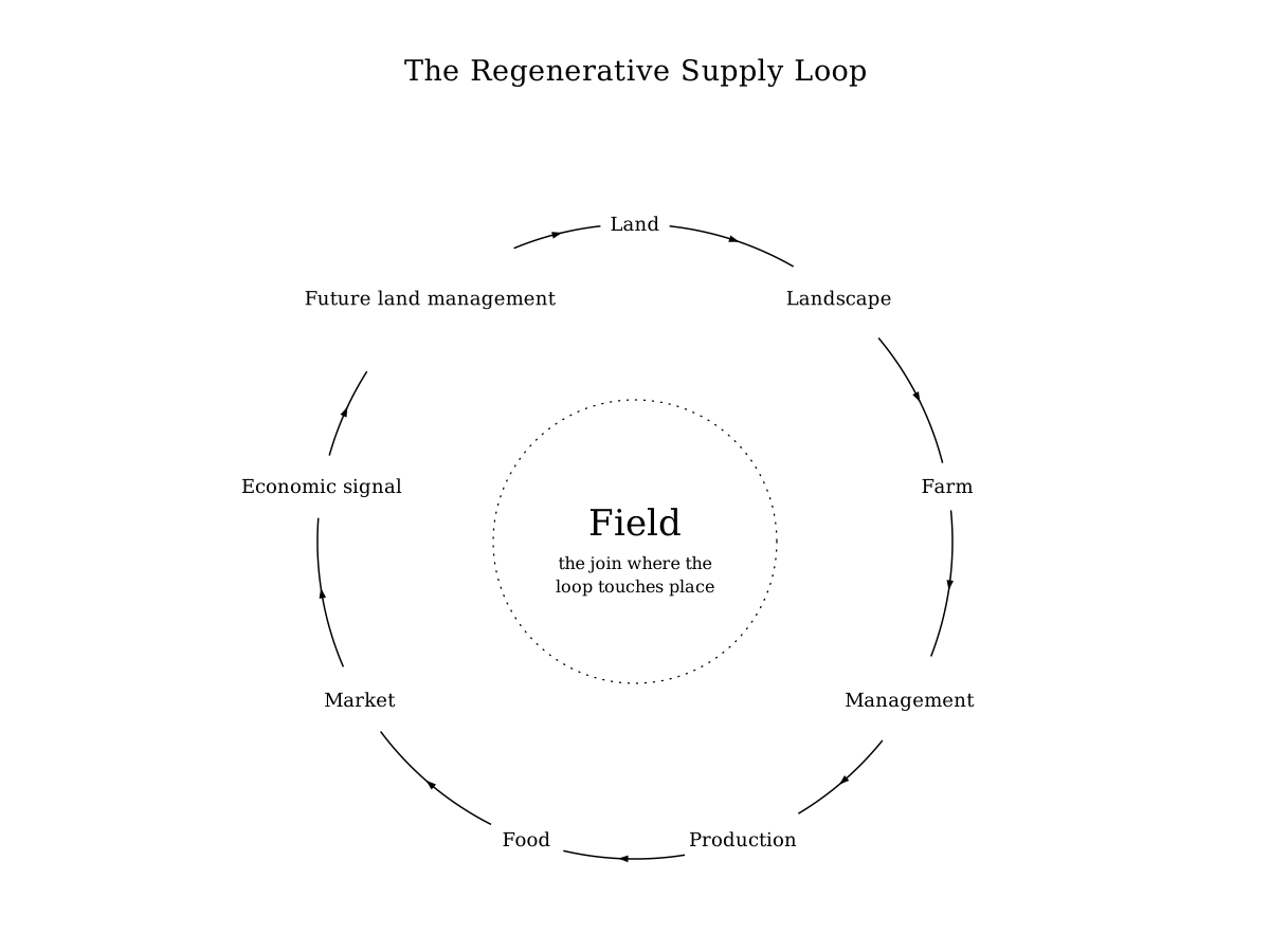
The final return to land is the reason this architecture matters. Markets influence what producers can afford to grow, what risk they can bear, what infrastructure they can invest in, and whether regenerative transitions can persist. Land management shapes production; production shapes food; food creates commercial relationships; commercial relationships generate signals that return to the next Production Cycle.
The network becomes regenerative when that return path is visible and economically meaningful.
Source Anchors
The Grove's architecture is designed to interoperate with, rather than replace, established public data and traceability foundations. The Watershed Boundary Dataset and NHDPlus provide hydrological structure; USDA NRCS SSURGO provides soil geography; USGS 3DEP provides elevation resources; USDA NRCS Conservation Practice Standards provide established conservation-practice definitions; GS1 EPCIS provides a supply-chain event vocabulary; W3C PROV provides a provenance model; STAC provides a catalog model for spatiotemporal assets; and OGC SensorThings provides a geospatially enabled observation model for heterogeneous sensors.
These standards and datasets do not define regenerative agriculture on their own. They provide durable building blocks that allow the network to avoid inventing new identifiers, spatial hierarchies, event semantics, or provenance concepts where strong public foundations already exist.
Reference Ledger
Living Edge
Field-level ecological reasoning
active
The next layer of design is to determine which landscape relationships should remain simple reference context and which should become first-class computational relationships, especially upstream/downstream hydrology, groundwater dependency, habitat connectivity, and field-level risk.
Buyer-to-field production planning
active
The market-making model needs a formal constraint and preference grammar that can express commercial, production, landscape, evidence, logistics, and economic requirements without creating an unmanageable procurement ontology.
Regenerative outcome science
inquiry
The evidence architecture should support multiple outcome frameworks while resisting the universal-score trap. The unresolved work is to define how locally relevant indicators, scientific models, repeated measurements, and program-specific criteria coexist cleanly.
Soil-to-food research
inquiry
Preserving production provenance makes food-composition research possible, but causal claims require study designs far beyond ordinary marketplace data. This remains a research branch rather than a product claim.
The Seed
Modern commerce asks what is being sold. A regenerative supply network must also ask where it came from, what happened there, what was observed, what is merely inferred, what changed, what the producer gained or risked, which landscape sustains the supply, and what the market should make possible next season.
The complete loop is:
LAND
  ↓
LANDSCAPE
  ↓
FARM
  ↓
MANAGEMENT
  ↓
PRODUCTION
  ↓
HARVEST
  ↓
FOOD
  ↓
MARKET
  ↓
ECONOMIC SIGNAL
  ↓
FUTURE PRODUCTION
  ↓
FUTURE LAND MANAGEMENT
  ↓
LAND
The field is the join because it is where that loop touches a real place. Everything else grows from there.